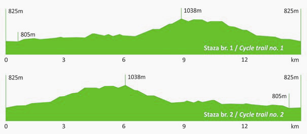
 Length: 15.3 km
Category: easy
Surface: 100% gravel
Duration: up to 2 hours
Location: eastern slopes of Učka
Start: Brdo hunting lodge 825 m above sea level
Finish: Brdo hunting lodge 825 m above sea level
Difference in elevation: 200 m
Starting and finishing at Brdo hunting lodge, the circular trails no. 1 and no. 2 have approximately equal length and similar lie of the land. Although not too demanding, these trails nevertheless require some agility and stamina. The calm and shade of a beech forest are never far away. So make up your mind and get going. Good luck!
Download the Učka Bike brochure
Download GPX track
Download KML track
| elevation (m a.s.l.) | Km | ||
|---|---|---|---|
| Brdo hunting lodge | 825 | 0 | |
| At the sawmill | left | 900 | 2,2 |
| Mountain pass | 1040 | 5,2 | |
| Turning for Vodička griža | straight – on the main road |
1010 | 5,8 |
| Učka Nature Park board | left from the main road | 940 | 7,6 |
| Popova voda | left | 8,0 | |
| Turning for the Bončić house | left | 850 | 11,4 |
| straight | 11,8 | ||
| left | 13,4 | ||
| left | 14,2 | ||
| Turning for Vela Sapca | right | 14,4 | |
| Brdo hunting lodge | 825 |
15,3 |

