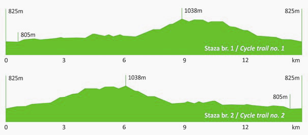
 Length: 15,3 km
Category: easy
Surface: 100% gravel
Duration: up to 2 hours
Location: eastern slopes of Učka
Start: Brdo hunting lodge 825 m above sea level
Finish: Brdo hunting lodge 825 m above sea level
Difference in elevation: 200 m
Download the Učka Bike brochure
Download GPX track
Download KML track
| elevation (m a.s.l.) | km | ||
|---|---|---|---|
| Brdo hunting lodge | 825 | 0 | |
| Turning for Vela Sapca | straight | 0,9 | |
| right | 1,1 | ||
| right | 1,9 | ||
| straight | 3,5 | ||
| Turning for Bončić house | right | 850 | 3,9 |
| Popova voda | right | 7,3 | |
| Učka Nature Park board | right on the main road | 940 | 7,7 |
| Turning for Vodička griža | straight – on the main road |
1010 | 9,5 |
| Mountain pass | 1040 | 10,1 | |
| At the sawmill | 900 | 13.1 | |
| Brdo hunting lodge | 825 |
15,3 |

