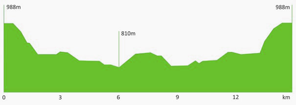
 Length: 17 km
Category: medium
Surface: 100% gravel
Duration: up to 2 hours
Location: western slopes of Učka
Start: Mala Učka 988 m above sea level
Finish: Mala Učka 988 m above sea level
Difference in elevation: 200 m
An ideal trail for recreational bikers, beginners and whoever wishes to enjoy magnificent views of Istria and Kvarner while cycling.
The route starts from the village of Mala Učka and runs along the gravel road towards Vela Učka. After 500 m it turns left in the direction of Bodaj, offering breathtaking views of the landscapes of central Istria and the top of Učka. From the peak of Bodaj the trail then leads back the same way to Mala Učka.
Download the Učka Bike brochure
Download GPX track
Download KML track
| elevation (m a.s.l.) | Km | ||
|---|---|---|---|
| Mala Učka | 0 | ||
| left | 990 | 0,5 | |
| left | 880 | 2,3 | |
| straight | 850 | 6,7 | |
| straight | 860 | 7,2 | |
| Bodaj | 900 | 8,5 | |
| right | 880 | 14,7 | |
| Road V. Učka – M. Učka | right | 990 | 16,5 |
| Mala Učka | 1000 |
17,0 |


